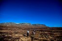
The mountain feeling
Calm, authentic and well-rounded.

Haugastøl 1000 MOH
Summer in Haugastøl offers great opportunities not only for cycling the Rallarvegen but hiking too. The surrounding area with the two national parks Hallingskarvet and Hardangervidda offer walks suitable for every level.
Calm, authentic and well-rounded.
Cycling experiences with quality.
Views, trails and high mountains right nearby.
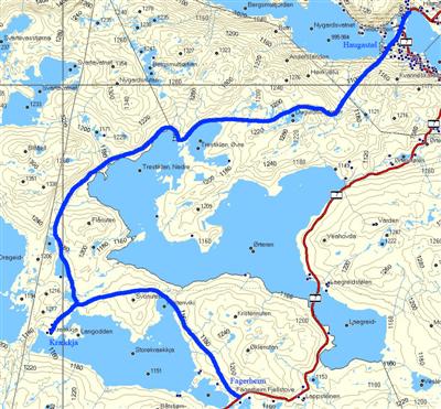
Map: The full route is on the Skarverennet hiking map 1:50 000, which can be bought at our reception at Haugastøl.
The path starts about 200 metres west of RV7 from Haugastøl.
The path is marked with red T and goes past Øvre and Nedre Trestiklan to the DNT cabin Krækkja.
The path continues along the north side of Storekrækkja lake to Fagerheim. For the return to Haugastøl you need a bus or other transport.
Map: On the Skarverennet hiking map 1:50 000, available at our reception at Haugastøl.
Take the bus or park at Lægreidstølen, 1147 m a.s.l. Parking on the right. The path goes over Monsbulægret and up to 1272 m a.s.l.
From Lægreid to Tuva is 12 km.
Tuva is a cosy tourist cabin run privately for two generations, with some of Hardangervidda's best waffles. You can continue on the path from Tuva to Ustaoset, 10 km.
For a shorter hike you can drive to Ustaoset and take the first right after the station, then continue to Ustebergstølen. From here a 7 km path leads to Tuva. For a summit trip you can go up Ustetind at 1376 m a.s.l.
Map: On the Geilo or Skarverennet hiking map 1:50 000, available at our reception at Haugastøl.
Follow RV7 towards the train station. Just after the level crossing you'll find a road going up to the left. The route is signed to Embretstølen. Follow the path up to Tjønngravtjørni (also known as Lillevann locally), then continue northeast towards Embretstølen. The path passes Kvasshovd and on to Langetjern. Fishing permits are available; buy them at Haugastøl reception. Good fishing!
Embretstølen has no catering. You can continue the hike down to Ustaoset.
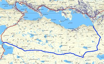
Length: 30 min boat trip from Halne to Sleipa. 1.5 hours from Sleipa to Heinseter, and 4 hours from Heinseter to Fagerheim.
Map: On the Skarverennet hiking map 1:50 000, available at our shop at Haugastøl.
For a different experience, a trip with Halnekongen across Halnefjorden might be right. Halnekongen crosses Halnefjorden, about 18 km west of Haugastøl. Take the boat to Sleipa. From here you can follow the path to Heinseter, usually about 1.5 hours. You can return to Sleipa and get picked up by boat, or continue from Heinseter to Lappsteinen or Fagerheim. That stretch takes about 4 hours.
If you only want a boat trip, joining Halnekongen for a return trip is a nice option.
This hike suits all ages.
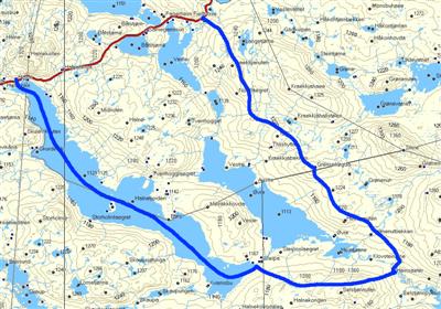
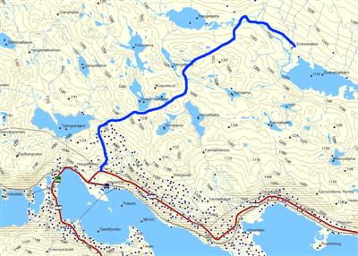
Map: On the Skarverennet hiking map 1:50 000, available at our shop at Haugastøl.
If you like fishing, bring your rod. There are several lakes where you can buy a fishing permit at the tourist centre reception.
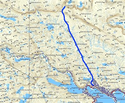
The path starts on the right side of Tjønngravtjørni at 1098 m a.s.l. (Lillevann).
This is a T-marked path through Folarskardet and down to Raggsteindalen, passing Bjørnebulægret and on to Lordehytten.
Lordehytta is a stone cabin built around 1880. The Irish Lord John Garvagh the younger had it built with the help of Lars Lein from Hovet. The cabin lies at 1620 m a.s.l. in Folarskardet on Hallingskarvet. You can only reach Lordehytta on foot. It takes about 3 hours from Haugastøl.
Lordehytta is in Hallingskarvet National Park, which opened in 2008.
Lordemarsjen is held in early August each year. See www.lordemarsjen.no.
The fittest can continue up onto the plateau of Hallingskarvet in good weather.
Check weather and conditions before you go. We have weather info and webcams.
Weather and webcamsHiking maps (e.g. Skarverennet 1:50 000) can be bought at our reception. Some hikes require bus or car to the starting point.
Contact us for hike tips and accommodation that suit your level and the season.